Tuesday, June 28, 2011

The system to the south has been creeping north during the day. There is no rain at the moment but it could get closer as the night progresses. The dry air is still sitting out in the middle of the Caribbean. Right now it looks like the rain is winning. However, tropical storm Arlene in the Gulf of Mexico will likely attract most of the moisture leaving Belize with no rainfall at all.
 A chunk of the Saharan Air Layer is now right in the middle of the Caribbean (image right). The image below shows an area of showers extending in Honduras. So there is going to be a battle between these two systems. Will update this situation later today.

Sunday, June 26, 2011

This is strange! A dust cloud from the African Sahara is approaching the eastern end of the Caribbean. Hope this does not mean a quick end to the rainy season!
In a previous report I mentioned that the tropical wave was poorly organized so what happened is that it broke up before reaching Belize leaving central Belize completely dry. The expected rainfall did not occur. But what is happening right now is that the upper air winds are beginning to shift. The direction is shifting from westerly to northerly. However it is too soon to tell if the shift is the start of the reversal. The westerly air flow is dipping far down into northern South America. This is not normal for this time of year.

Saturday, June 25, 2011

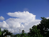
Here is an example of the effect of the present wind shear pattern. Picture was taken facing south. The top of the cloud is being blow off to the east. This means that the wind shear is from the west. This is not normal for this time of year. The top should be pointing west, not to the east.
Posted by Picasa
The tropical wave front has just reached the eastern tip of Honduras. It is making slow progress and is poorly organized. The upper section of the wave is encountering a heavy wind shear. The shear over Belize has become very light but still from the NW. The wave should show some development tonight as it approaches Belize.

Friday, June 24, 2011

The weather system discussed this morning has weakened during the day. There may be some showers before sunrise, however, heavy rain is not expected. I am predicting only about 38 mm of rain from this system.
There is a disturbance developing in the SW Caribbean that could start to affect Belize this weekend. It is forming ahead of a Tropical Wave. The limiting factor is that there continues to be a significant westerly wind shear above this disturbance. Will update this report later today.

Monday, June 20, 2011

After midnight a storm cell developed just south of Belize and moved straight north directly through the country. This morning I measured 1.76 in (44.7 mm) of rain. Should clear up by noon. The Caribbean is fairly quiet this morning. The rest of the week should see good weather.

Sunday, June 19, 2011

The tropical wave has passed Belize and moved off to the west. My previous report predicted 4 inches of rain from this wave. This morning I measured 4.5 inches of rain or 116 mm. At the moment I am watching a disturbance just entering eastern Honduras. To soon to tell if it will expand north and affect Belize.

Saturday, June 18, 2011

The tropical wave mentioned previously is beginning to affect Belize. A more extensive area of rain should move closer to Belize later today.
I am expecting about 4 inches of rain by the time the system clears late tomorrow. Will update this as conditions change.

Thursday, June 16, 2011

Wet Weekend?

A complex weather system is developing. There is a pair of tropical waves approaching. The High Pressure to the north is moving off to the east. This should allow some wet weather to move in for the weekend. Also at this same time the Upper Air wind pattern is beginning to shift to the rainy season configuration. This combination of events should create some interesting weather over the next 4 days.

Tuesday, June 14, 2011

The area of dry air in the Caribbean is rapidly shrinking. The good weather we are having may not last much longer. Computer models of the Upper Air show the air flow shifting to retrograde motion this weekend. That is, the Upper winds will start flowing from east to west. This will bring with it more stormy weather. Will be keeping a close eye on this development.

Monday, June 13, 2011

Belmopan Thunderstorm

What looks like the beginning of the real rainy season was an isolated event that affected only Belize and specifically, Belmopan, last night. The image to the right shows the extent of the storm. The storm actually developed directly over Belmopan, it did not move in from some place else. It then expanded out in all directions as shown in  the image. The time of the storm was from just before 3AM and lasted until 4:40AM. I measured 132mm of rain or 5.2 Inches at my location. At sunrise this morning there is an even larger storm cell developing in southern Belize. This storm is affecting mainly Belize itself. The surrounding areas remain relatively dry. In fact the whole of the Caribbean is under the influence of a very dry air mass. See the images, the pale blue area of the TPW (total precipitable water). The other image is the storm area in the south. The storm is expanding northward and now producing more rain in Belmopan. There is still a westerly wind shear but it is much weaker than a few days ago. Don't know what is going to happen next!

Sunday, June 12, 2011

The sun is almost blank except for one tiny spot. This is not good news for ending the drought in this area. Need an active sun plus full moon to start off the rainy season. There is a Total Lunar Eclipse of 2011 Jun 15 (Africa time) but not visible here or in North America. I did not hear the thunder Friday night as I was watching a DVD on my computer with headphones so missed those long duration thunders. Hugh's analysis of the thunder was pretty good. Currently I am watching a storm area just south of Honduras which seems to be expanding northward. Weather-underground is predicting a 90% chance of a thunderstorm here tonight. I will report on this later today. Don

Saturday, June 11, 2011


The top image is that of the Wind Shear Tendency. The blue at the bottom is low or no shear and the red-orange is high (from the west) shear. The area of high wind shear is slowly moving northward. Belize is entering the area of lower shear and possibly soon a reverse shear. The lower image is that of the Saharan Air Layer. The darker the orange area the drier the air. Right now the Caribbean is showing unusually dry air for this time of year. Not good news for ending the drought. Plus it looks like an Omega block is forming the same as what caused the below normal rainfall from December to February. This would push any tropical waves to pass below Belize. Want to see what happens after the full moon on June 15.

Friday, June 10, 2011

The water vapour stream flowing westward off the coast of Africa has become weaker. Too dry for this time of year. The stream should be darker and thicker. No sign of the rainy season starting yet.

Wednesday, June 8, 2011

<< STORM WARNING: NOAA forecasters estimate a greater than 25% chance of geomagnetic storms on June 9th. That's when a CME from the magnificent flare of June 7th is expected to deliver a glancing blow to Earth's magnetic field.>>
Last weekend's Low Pressure has moved off to the north and northwest. Higher pressure off the east coast of Central America has returned Belize to dry conditions. There are no more tropical waves approaching any time soon. The only activity to watch is these sun flares. Not sure what affect if any they will have on our weather.

Monday, June 6, 2011

This morning I measured 19.5 mm (0.77 in) due to last nights rainfall. The weather system is very complex. Moisture at the surface is flowing in from the north east, rising then getting caught up in the Upper Air outflow from the Low pressure south west of Jamaica. The outflow is offset to the south west of the Low itself. The offset is acting like an anchor to the Low holding it back from moving north. This is a disturbing situation. The pattern is similar to the one of hurricane Richard last October. I do not know what is going to happen. Should know by Wednesday. That Monsoon Trough is an interesting feature.

Sunday, June 5, 2011

Sunday rain as predicted

An area of rain developed over Belize this afternoon, probably as the result of the tropical wave mentioned a few days ago. The wave seemed to have passed right through the stationary Low Pressure situated south of Jamaica. The wave had disappeared from the NOAA surface map but must have flared up due to the heating of the land mass of the Yucatan. Will check to see how much rain this system produces in the morning.

Thursday, June 2, 2011

Weather Collision

An interesting pattern is developing. The Tropical wave is progressing westward and headed directly for a stationary Low Pressure that is in line with a trough connected to the ITCZ. This could set off a line of thunderstorms. I am looking for some active weather here in Belize on Sunday. Will keep watching this one.

Wednesday, June 1, 2011

It is June 1 and the beginning of the hurricane season. A weak trough of low pressure developed over Belize this morning allowing some morning showers to move in from the north east. Also the moist air to the south has expanded northward during the night. The rainfall measured due to this morning's showers was 22.8 mm or 0.9 inch.
The ITCZ has also moved northward somewhat ( stripped ribbon)

The surface of the sun is becoming pepped with small sunspots, an indicator of increasing solar activity. This should start stirring up some more active weather in the Caribbean.