Tuesday, December 31, 2013

A massive area of very dry air is fighting its way westward towards Belize. But at the moment there is some low level moisture wandering around the coast of Belize causing some outbreaks of showers. What is complicating the weather situation is an area of very cold Arctic air that was supposed to plunge southward but has somehow stalled over the Great Lakes region. The movement of weather at the moment continues to be restricted. This same restriction is what caused the severe flooding in the West Indies the middle of last week.

Wednesday, December 25, 2013

A weather blocking pattern has been set up. The Low Pressure that was moving westward from the eastern Caribbean has suddenly froze in position and in fact has been pushed back to the east a few hundred kilometres. So Belize is now under the influence of stable dry air. Not sure how long this block is going to last.

Monday, December 23, 2013

There is a forecast for rain tonight but not quite sure were it is coming from. There is a cold front approaching the Yucatan which could trigger some rain. However, approaching from the east is an area of strong subsidence, so any rain is likely to be just brief showers. Will have to see what things look like in the morning.

Tuesday, December 17, 2013

There is a storm cell developing off the southern coast of Belize that looks like it might be a threat. Will issue an update on this if required. The cell is situated in a frontal trough so there is potential for intensification.

Sunday, December 15, 2013

There was a break in the rainy weather yesterday with sunshine most of the day. But rain moved in again this morning before sunrise and at 9 AM have measured about 20 mm. The total rain fall since last Tuesday is now 4.7 inches or 120 mm. The ground is now even more saturated than previously. Evaporation has been low over the past month due to lack of sun and light winds. The upper air at the moment is streaming up from the SSW while at the same time a cold front is pushing down from the north. Not sure what is going to happen next.

Wednesday, December 11, 2013

The weather system mentioned previously has intensified is is now producing heavy rain showers over Belize. Will send an update later tonight.

Tuesday, December 10, 2013

After several weeks of no significant weather except for a few light showers, a change is about to occur. There is a narrow band of very dry air to the east of Belize and encroaching into this is an area of active weather. Entering into the northern Gulf of Mexico is a very cold air mass which is pushing south. Looks like there is going to be a collision between these weather systems and this could result in some heavy rainfall over the next few days. To complicate things, a large coronal hole is opening up on the sun which should cause a strong solar wind to hit the Earth towards the end of the week.

Saturday, November 23, 2013

The weather has been fairly dry since my last report but as of yesterday Belize has become surrounded by some moist air and right now an area of rain is moving in from the north. Nor likely to produce much rain as the weather system is not very persistent. We may only receive about 12 mm from this tonight.

Sunday, November 10, 2013

Another situation where a trough of low pressure is passing under a Upper High Pressure located in the northern part of the Yucatan. Measured almost 2 inches of rain overnight and up to the present time. The weather should become drier once this system passes. According to science investigator James McCanney, strange weather events may begin to occur towards the end of the month as comet ISON makes its closest approach to the sun and thereafter forms a critical alignment. Will keep a watch on this situation.

Sunday, November 3, 2013

The cold front is drifting off to the east allowing the cooler and drier air to flow in behind. There was no rain associated with the front here in Belmopan. The trough of lower pressure off to the east has weakened and will now move off to the north and east. So to me it looks like the weather will just be cool and dry for a few days.

Saturday, November 2, 2013

A strong Cold Front is approaching Belize from the north west. Also there is a trough of low pressure off the the south east with a band of dry air in between. The two systems appear to be converging. This should provide for some interesting weather over the next 24 hours. Will update in about 4 hours.

Sunday, October 27, 2013

The Upper Air ridge that has been trapping all this rain in a trough beneath it, is slowing dissolving so we should get a few days of better weather. However, there is another tropical wave off to east of the Caribbean which may cause some trouble sometime late Thursday into Friday.
More heavy rainfall this morning. Storm centred south of Dangriga. Belmopan actually on the northern edge. Must be some serious flooding to the south. Have measured 110 mm or over 4.3 inches for last night and up to 10:30 this morning. Three day total now about 13 inches. The storm cell should now begin to dissipate.

Saturday, October 26, 2013

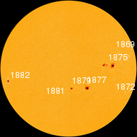
The sun has bee very active over the past few days. THE NEXT THREE DAYSSolar activity remains high. Sunspot AR1882 is crackling with M-class solar flares and poses a threat for more X-flares. The sun is turning this sunspot toward Earth. Over the next three days (Oct. 26-28), a series of CMEs created by the recent limb eruptions will deliver glancing blows to Earth's magnetic field, possibly sparking polar geomagnetic storms.
Moisture is still being trapped under a upper level anticyclone circulation and produced more rainfall last night, measured 2.35 inches or about 60 mm. The ground is now very saturated. There is clearing taking place starting in the south and moving north.

Friday, October 25, 2013

Heavy rainfall last night around Belmopan, measured 124 mm, total so far since yesterday is 6.2 inches or 157 mm. There is an upper air anticyclone circulation centred in southern Mexico setting up a block and uplifting the moisture flowing inland along the coast. The cold front remains just north of the Yucatan. The rain should be decreasing during today due to reduced convection.

Thursday, October 24, 2013

Seems like the cold front to the north has approached closer to Belize than expected. The previously mentioned tropical wave looks like it is colliding into the southern CW outflow from the cold front and generating some active weather over the land area. This is generating some significant rainfall. Also! SOLAR FLARE! Solar activity is high. On October 24th at 00:30 UT, Earth-facing sunspot AR1877 erupted, producing a powerful M9-class solar flare. NASA's Solar Dynamics Observatory recorded the blast: This could have helped trigger the development of the weather system.

Wednesday, October 23, 2013

The air to the east of Belize is still pretty dry (yellow area). A tropical wave is approaching but the top end of it has very little moisture. To the north is the remains of a cold front soon to be reinforced by a fresh outbreak of colder air in the southern States. Belize may get some rain but probably not very much due to lack of strong convection.

Saturday, October 19, 2013

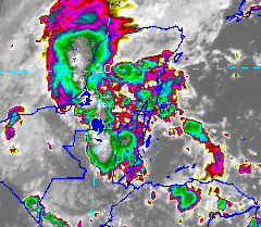
Since the 22nd of September there has been only 43 mm of rain. A large upper air cell of High Pressure has been sitting over the central Gulf of Mexico keeping the area around the Yucatan dry for the past 3 weeks. This cell has finally started to collapse allowing more moist air to flow into the NW Caribbean. Will follow this change in air mass to see if there is a return to rainy weather.

Wednesday, September 18, 2013

The area of active weather has drifted to the north west, with only a slight affect on Belize. Measured only about 13 mm of rain. Weather should improve over the next few days.

Monday, September 16, 2013

Back to updating this blog again. Was in Canada from August 15 to September 11 so missed experiencing the wet weather here in Belize during my absence. Rainfall records show that there has been almost 2 feet of rain here in Belmopan since August 14, 2013. Now watching the area of active weather off the north east coast of Honduras. Will report on this disturbance in the morning.

Monday, August 12, 2013

Band of thunder showers moving across central Belize including Belmopan area. Last night the Belmopan area received almost 40 mm of rain and the rain right now is going to add to this. Will report again later today.

Saturday, August 10, 2013

The western Caribbean is very low in water vapour at the moment. Belize is dry. Rainfall for July was well below normal at only 182 mm and so far in August only 10 mm. There is a tropical wave forming in the far eastern Caribbean which I will be following over the next few days.

Wednesday, July 24, 2013

Since my last report there has been an increase in the level of moisture affecting Belize. For the past 9 days there has been frequent but mostly brief rain showers. However today the shower activity has been more intense. A series of thunder showers moved in from the Gulf of Honduras with Belmopan being on the northern edge of this band of showers. Rainfall for today was 12 mm or 1/2 inch. Since July 13, the total rainfall has been almost 70 mm. The ground is now pretty much saturated.

Thursday, July 4, 2013

Thunder Shower last night

A trough of low pressure had become trapped and locked under an upper ridge and storm cells form overnight and move northward up through Central America across Belize and the Yucatan. Measured 21 mm of rain from a Thunder Shower last night in Belmopan. Off to the east in the Caribbean the weather is very dry. So the rain over Belize is a welcome relief. The image shows the position of the cells sometime after midnight last night.

Monday, July 1, 2013

drought alert

The Caribbean looks pretty dry. To the far east end it is extremely dry. Do not see any more rain once the current wave has passed by. The rain shower at 1 PM produced 20 mm of rain.

Tropical Wave

Its July 1 and a weak tropical wave has arrived in Belmopan at 1 PM with a moderated rain shower. Belize should experience scattered showers over the next 24 hours. Once this wave has passed, dry air will be returning since dry air from Africa is approaching the eastern Caribbean.

Thursday, June 27, 2013

The Caribbean is lacking any moisture right now. Not sure how the next weather system is going to develop. The air flow off the west coast of Africa is quite dry and dusty right now. We could be returning to a drought condition. I am still holding back on doing any planting in my garden, just doing weed control.

Tuesday, June 18, 2013

The weather system mentioned previously, named TD2, produced a 48 hour total rainfall of 5.8 inches or 148 mm . This was more rain than the 2-3 inches originally forecast for the tropical wave only. Did not anticipate the formation of a tropical depression which passed directly over Belize along with the wave.

Monday, June 17, 2013

The weather system described a few hours ago seems to become almost stationary and is dumping far more rain on Belmopan than expected. Plus a new storm cell is forming off shore SE of Dangriga.
The remains of Tropical Depression 2 now producing heavy rain over the northern half of Belize. The rain should soon start to taper off in the Belmopan area. By morning the weather system should have moved out the area. Will report on the total rainfall for TD2 in the morning.
A Tropical Depression has formed along the previously mentioned Tropical Wave. Continuous moderate rain now falling on Belize. Forecast to continue for the next 36 hours.

Saturday, June 15, 2013

The tropical wave is now approaching Belize. Should reach here tomorrow morning. Once over Belize the wave may slow down and produce several days of rainy weather. This may be the last good rain for several weeks because the air behind this wave is quite dry all the way to Africa. I am predicting 2 to 3 inches from this wave over a period of 3 days.

Friday, June 14, 2013

We have been under the influence of a High Pressure ridge today, however, it now appears that a Tropical Wave is headed towards Central America and Belize. There is a fairly strong upper level outflow at the base of this wave. Going to keep a close watch on this one.

Wednesday, June 12, 2013

QUIET SUN: With the sunspot number dropping to almost zero, solar activity is very low. No strong flares are expected today. The solar wind is at 401 km/s. Weather is sunny with a few light scattered showers.

Tuesday, June 11, 2013

A thunder shower formed around Belmopan last night with rain between 0300 and 0500 hrs, measured 31 mm. There was also a larger area of showers in the southern part of Belize. Otherwise, the Caribbean basin itself is relatively dry.

Monday, June 10, 2013

The Caribbean side of Central America is relatively dry compared to the Pacific side. We are in a blocking pattern which is vaporizing any tropical waves moving westward off Africa. Not sure how long this is going to last. The solar storms on the sun have all died down so the sun has once again become very quiet. My prediction of a dry June for the Belmopan area of Belize still holds. Already 1/3 through June and have measured only 12 mm of rain.

Monday, June 3, 2013

Light rain last night, only 3mm from system moving SW to NE up the coast of Belize. The image on the right indicates the TPW ( potential for rain) the black band nearly follows the Monsoon trough. The solar wind yesterday reached over 750 km/s but this morning is down to 660 km/s. There looks to be drier weather headed this way. I am going to make a wild prediction that the rainfall for June could be less than the total for May.

Saturday, June 1, 2013

A large storm cell did develop. It formed in Mexico as shown in image. There was only some high cloud in Belmopan. The storm cell should disappear overnight.
Conditions appear favourable for some sort of weather development over Belize during the next few days. The Solar Wind has already begun to increase and has doubled in the past 36 hours. It is now up to 640 km/s, similar to last weekend. The surface circulation is CCW and there is a CW outflow above this. The wind shear is much lower compared to last weekend. All this adds up to something brewing in the atmosphere.

Wednesday, May 29, 2013

TS Barbara weakening. Over Belize just high cloud (altostratus) with a few drops of rain. Weather in the Caribbean much quieter than 4 days ago.

CORONAL HOLE: A hole in the sun's atmosphere--a "coronal hole"--has opened up and it is spewing solar wind into space.
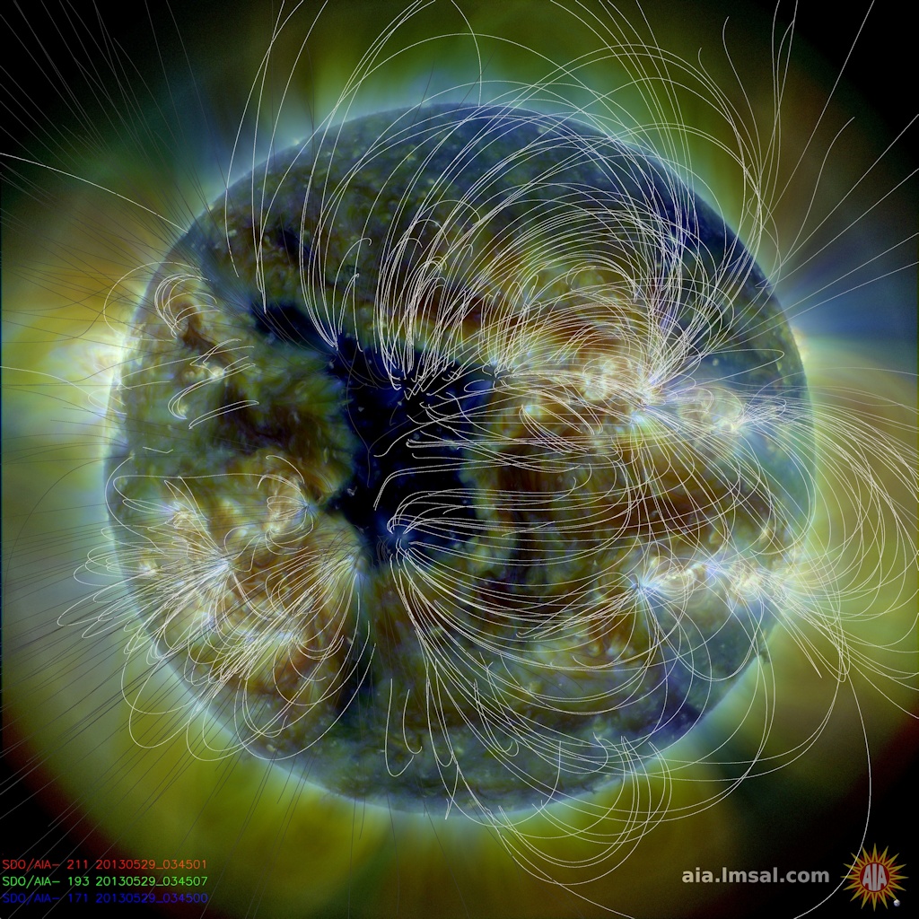
Coronal holes are places where the sun's magnetic field spreads apart and allows solar wind to escape. A windy stream of plasma flowing from this particular hole should reach Earth on June 2-3.
Lets see if this has any affect on the weather when this event hits us.
Unusual weather situation. The motion of these systems is from the southwest to the east / northeast. This means the storm off the south Mexico coast is moving towards the coast. Wonder how far inland it will move.

Tuesday, May 28, 2013

The storm cell mentioned last night moved northward inside the coast of Belize dumping a lot rain in the process. Here in Belmopan I measured 69 mm or 2.7 inches of rain. The total rain for May now is 8.5 inches or 217 mm. The weather conditions over the past 3 days has been very complex. Development was rapid and coincided with the rapid increase of the Solar Wind and Electron Storm. Not sure if there was a connection.

Monday, May 27, 2013

Storm moving into the Toledo area. May cause some local flooding. Here in Belmopan I have measured about 88 mm of rainfall in past 24 hours. Solar Wind speed right now is a remarkable 777 km/sec but not sure how this is affecting the weather here. Strange weather, this low level surface rain is trapped under a Upper Level High Pressure off the coast of Honduras.

Sunday, May 26, 2013

Rainfall last night around 3:30 AM along with strong wind. Image shows the storm cell as it was approaching Belmopan. Around 4 AM the cell expanded resulting in a period of light rain. Measured 1.3 inches or 34 mm .A cold front pushing into the west Atlantic is rotating moisture from east to west into central America and up into Belize.

Saturday, May 25, 2013

The upper air Wind Shear is quite strong right across the whole Caribbean. This is squeezing the main band of active weather further to the south and southwest. There have been brief and scattered showers across Belize today from low cloud, measured 10 mm rainfall.

Thursday, May 23, 2013

The upper air water vapour is now on the increase, nevertheless most of the Caribbean is still fairly quiet. There could be an increase in activity by tonight.

Sunday, May 19, 2013

The cluster of active sunspots is rotating away. The activity has been short lived. Also the solar wind is decreasing. No end to the dry season is yet in sight. The tropical rain band is still far to the south. Not a good situation for an end to the dry.

Wednesday, May 15, 2013

The sun is beginning to become more active by sending out some X-Class solar flares, the first ones of the year. This activity could increase the possibility of some stormy weather in this region in a few weeks time. The current dry season has been quite severe and we need rain soon. The sun is suppose to be at its maximum with respect to solar activity, however, the activity has been well below normal.

Saturday, May 4, 2013

The storm cell of May 2 proceeded a cooler and drier air mass that has pushed all the way down to the middle of Nicaragua  The image shows the boundary between the cooler air in blue and the more tropical air to the south. The mid west US are experiencing some unseasonably cold weather with snow.

Thursday, May 2, 2013

Today was another hot day similar to yesterday. A storm cell has developed north of Belmopan. Right now at 8:50 PM we are having strong gusts of wind. There is some signs of lightening and there was a heavy rain shower for about 7 minutes around 9 PM. There is a strong wind shear from the SW tearing the top off this cell and this may limit any further development. Rainfall from storm in Belmopan only about 7 mm. Heavier rain to the east and south.

Wednesday, May 1, 2013

This looks like a big storm but it is not. It is just a lot of water vapour in the upper air, very little of it is falling as rain. Total rainfall for the month of April for Belmopan was only 18 mm. Today was very hot, just over 100F. The landscape is turning a burnt brown colour. The total rainfall since the beginning of last November is only 58 cm or about 23 inches. Not a good situation.

Wednesday, April 17, 2013

Hot and dry weather of the dry season continues. Solar activity remains abnormally low.