Sunday, April 12, 2015

This weather site is being closed down on April 30, 2015 due to changes in my Google Account. The new site can be found at the following ::: <<< weathertricity.blogspot.com >>>
The upper level trough has moved south and east and is now further away from Belize. Belize remains dry with most of the active weather down in the Panama area. The polar circulation has change very little over the past 4 days, The CW rotation is at 77.3 N / 105.4 W and the the CCW near Siberia at 64.0 N / 73.9 E.

Thursday, April 9, 2015

There has been an increase in the moisture in the Caribbean. An upper air trough of Lower Pressure is forming as shown in the lower left image. An increase in convection is expected over the next few days. The Sahara air off Africa is weakening.
Polar Circulation update: The CW High Pressure is dominating again and has rotated back again towards the North Pole. Now centered at 75.8 N / 100.8 W. A strong active cold front is pushing down from Canada. Severe weather warnings issued.

Saturday, April 4, 2015

The total rainfall from last report weather system due to cold front was 70 mm which is quite a lot of rain for this time in the dry season. Now Belize is back in the dry again as seen in the water vapour image. Meanwhile there has been a big change in the polar circulation. The CW loop has become much weaker and moved off to the north and west while the larger CCW loop and now got a double centre and has expanded. This looks like there will be colder than normal temperature for Canada over the coming week.

Tuesday, March 31, 2015

Around 1340 hr a large area of rain showers passed through the central part of Belize. Belmopan experienced a fairly heavy rain shower along with gusty winds. There was about 9 mm in 15 minutes. The tail end of the cold front must be stirring up some active weather.

Sunday, March 29, 2015

The lower circle is the CW rotation which is continuing to dominate while the old CCW over in Siberia continues to struggle.
The cold front crossed Belize Friday night and stalled east of Honduras. The front is now beginning to dissipate. Since Friday night, here in Belmopan I measure about 52 mm of rain which is pretty significant for this time of year. We don't normally get such a strong cold front this late in March.

Friday, March 27, 2015

A strong Cold Front is approaching the Yucatan. This may bring some significant rainfall to Belize. To soon to determine how much rain.
The CW polar circulation continues to strengthen. Now cemtred at 67.8 N / 117.8 W
Eastern Canada is still unseasonably cold.

Tuesday, March 24, 2015

The polar circulation is definitely beginning to make a big change. The change seems to be in step with the spring equinox. The winter time CCW pattern is fading away while the summer time CW pattern is beginning to dominate.
The Caribbean continues to be very dry, there is no sing of rain anywhere at this time.

Sunday, March 22, 2015

There has been little change in the Caribbean with respect to the low level of water vapour.
However, there is a big change occurring in the polar circulation. The larger CCW rotation is still close to Siberia, while the CW rotation near Alaska is becoming significantly larger. Only the eastern part of Canada is experiencing cold weather.

Wednesday, March 18, 2015

High cloud from the Pacific side is flowing northward across Belize. Low level cloud is moving in from the Gulf of Honduras across southern Belize but no rain due to the upper air being very dry.
The polar circulation has moved further into Siberia, now centred at 72.2 N / 100.2 E. This is putting the jet stream further north now, more over the Great Lakes and New England. The southern states is now much warmer.

Saturday, March 14, 2015

There was some significant showers last night around Belmopan from 0230 to 0430. Measured about 12 mm rainfall. The yellow arrow points at the low cloud system responsible for the rain. The system was amplified by a weak trough passing across the Yucatan.
The CCW polar circulation is continuing to strengthen. Now centred at 86.6 N and 174.8 W and very close to the North Pole. This will produce some below normal temperatures across Canada.

Thursday, March 12, 2015

The polar circulation is changing again this time more like returning to a winter time pattern rather than shifting to spring time. The centre is at 84.6 N / 154.0 W. This could mean that North America could plunge back into cold again after a few weeks of milder temperatures.
The Caribbean is still dry. The showers predicted in my last report did not occur.

Tuesday, March 10, 2015

 There is a cluster of showers moving into the Gulf of Honduras and this may generate a few showers overnight in Belize. There is a cold front cutting across the Gulf of Mexico which will most likely stall and move back as a warm front. I am expecting only about 4 to 5 mm rain in Belize tonight most likely before sunrise.

Monday, March 9, 2015

The Caribbean basin has had a noticeable increase in the level of water vapour. Belize has been experiencing a few light showers during the hours before sunrise. There was 4 mm of rain last night. There has been a significant change in the upper air polar circulation. The CCW rotation is smaller in size and is more in a east-west orientation. This is allowing much milder air to flow across the US and southern Canada.

Friday, March 6, 2015

The southern Caribbean basin is extremely dry (shown as black in the image). The polar circulation is beginning to change. It is swinging off the east coast of Canada. The western side of North America is experiencing warmer temperature and the east is not as cold as it was a few days ago. The record breaking cold may be over for now.

Friday, February 27, 2015

Its the last day of February and North America is still dominated by Arctic Air. The polar and jet stream pattern has remained virtually unchanged over the entire month. The Caribbean as shown in the water vapour remains extremely dry. The lower images show a cold front as of last night and on the right the same cold front today which has not moved and will now likely just disappear or retreat back to the north as a warm front. Seems like the Earth's weather systems get locked into a pattern and just sit in one place for extended periods of time. This is not a good sign. The planet's atmosphere needs to be dynamic to be healthy.

Monday, February 23, 2015

The images show the upper air at 10 mb pressure level. The red arrow is the boundary between the North and South hemispheres. The green arrow in the south is the direction of the circulation. The upper right is South pole where there is very light winds. The lower left is the north pole where the circulation has changed very little during the month of February. The large CCW center is at 81.2 N / 7.3 W and the small CW circulation on the west coast of NA  is now at 56.4 N / 134.3 W . The pattern has resulted in continuous record breaking cold in the east and above normal temperature in the west. The Caribbean in now getting warmer and continues to be very dry. The trade winds are beginning the get stronger.

Thursday, February 19, 2015

The cold front passed through Belize overnight with just a trace of light rain. This morning is cool and cloudy. The red line shows the final position of the front where it will dissipate on Friday. Eastern North America is experiencing record cold. The cold CCW polar circulation has been expanding and is now at 77.7 N / 68.6 E and elongated while the warmer High cell has weakened and moved back more towards Alaska at 49.4 N / 160.7 W this is allowing the cold arctic air to invade far to the south and spread further west.

Tuesday, February 17, 2015

The Cold Front is shown by the yellow line. There is a minor wind shift line as show by the red line. The cold front will bring a sharp drop in temperature beginning on Thursday. The night may remain cloudy so the nighttime temperature may not be too cold. The polar circulation has changed very little so eastern North Am remains extremely cold, even record cold in some places.

Monday, February 16, 2015

A new Cold front has just entered the Gulf of Mexico. The front is suppose to reach Belize sometime Wednesday night. We should be getting some hot daytime temperature before the front arrives then much cooler the following day.

Sunday, February 15, 2015

The upper air polar circulation is pretty much in the same position as before the large CCW is now at 79.1 N / 53.7 E and the smaller CW has moved NW slightly to 52.0 N / 137.0 W. The strength of the polar Low Pressure is keeping the east part of North America in the deep freeze (almost record cold). Belize is still under the influence of a cold High Pressure which is centered at 27.2 N / 91.3 W this is producing warm sunny days and very cool nights ( 16 to 18 C). The temperature is forecast to increase briefly ahead of a new Cold front due mid week.

Wednesday, February 11, 2015

The Water Vapour image shows that the Caribbean is extremely dry. Any significant rainfall may be 10 days away. The clear sky over Belize has brought bright sunny warm days and very cool nights. The lower image shows that the polar CCW circulation has shifted more towards the north pole from the previous location closer to Siberia. It now centered at 82.5 N and 25.4 E. Meanwhile the CW circulation has shifted to the south and east and is now over British Columbia at 58.5 N and 128.8 W.

Saturday, February 7, 2015

Here is the latest image of the Upper Air polar circulation at 10 mb. The center of the larger CCW circulation is at 74 N / 71 E and the smaller CW circulation is at 62 N / 147 W. What I think is going to happen from now on is that the CCW system will slowly become smaller and the CW system will grow larger and eventually dominate as the summer season approaches. In the southern hemisphere, the opposite should take place.

The red arrow points to the wind shear line which is actually a trough of lower pressure. The High is south and west of Belize and this is what is producing the cold air flow. The trough is rotating CCW slightly so tonight will be very cool since the cold High will dominate.
The red line in the image is the wind shear line. West of the line is the cool air mass and the east side of the line is the warmer air mass. The line is forecast to gradually weaken allowing the warmer air to extend further to the west. Belize should be in warmer air tomorrow. The line is actually a ridge of high pressure. Cold air is flowing down on the west side.

Thursday, February 5, 2015

There is a wind shift front at the tip of the red arrow but the wind is very light here in Belmopan so the shift is not very noticeable, just a sight drop in temperature and a few drops of rain. Not as much rain around Belize as I expected. The white areas in the right image show where there is some rain. Maybe we could get some rain after midnight.
A wind shift line passed through Belize sometime before sunrise and now lies out in the Gulf of Honduras. The associated cold front is still north of Belize. The shift line was clear this morning but this afternoon the line is beginning to break apart. Have been hoping for some rain from this system but no rain is in sight at this time. There is not even any convection. Maybe there will be some rain tonight.

Tuesday, February 3, 2015

High Pressure in Caribbean centered at position of 20.5 N and 80.9 W or just south of Cuba. Belize is in an area of low water vapour. The upper air polar low pressure is centered at 78.7 N / 63.1 E, A high pressure cell is forming near Alaska. North America is experiencing very cold temperatures. A Cold front is expected to cross Belize this coming Wednesday night.

Saturday, January 31, 2015

 The upper air polar Low is now centered at 74.9 N and 74.0 E and is on the Siberia side of the North Pole. The diameter of this circulation has been shrinking over the past week.
There is a mid level High Pressure east of Belize. The nights are not as cool as a few days ago due the the southerly return flow. The next Cold front is not due until later this coming week. Hope it will bring a few showers with it this time.

Tuesday, January 27, 2015

Cold High Pressure in the western Gulf of Mexico at 24.7 N / 95.9 W pouring very cold air down over Belize. Tonight be the coldest night of the winter season. The leading edge of the cold air is predicted to weaken starting tomorrow.

Monday, January 26, 2015

A powerful storm is developing off the east coast of the US as shown in the images. A series of fast moving Cold Fronts are invading the Gulf of Mexico keeping the weather in Belize cool and cloudy. The cloud cover is helping to moderate the night time temperature for tonight. However, for Tuesday night and Wednesday the nights may be very cool. Need some warm blankets.

Saturday, January 24, 2015

The position of the Cold Front can be seen in this cloud water image as the orange band from western Cuba to northern Honduras. The front will move a little further to the east and then become stationary before dissipating later in the week. The purple area in the upper part of the image is the location of the coldest and driest air.
This morning the cold front has crossed Belize and is now just off the coast and pushing into the Gulf of Honduras. Belize will be much cooler over the next 5 days as a strong High Pressure drifts across the north west Caribbean. There was only a brief light shower due to the passage of the front. The image on the right shows that the upper air polar circulation has changed over the past few days and has moved more towards Siberia.

Friday, January 23, 2015

A strong Cold Front (cold air in red) has almost reached Belize. High Pressure will build in behind this front keeping Belize very cool for the next 4 days. This will likely be the coldest period for Belize this winter season. The warm air (yellow) will be pushed to the south. Not sure at this time if we will experience much rainfall. Will see what happens in the morning.

Saturday, January 17, 2015

The western Caribbean has become much drier. Since December 25, 2014 I have measured 258 mm of rain or about 10 inches. This rainy period may now be over and the dry season is now beginning to take over. The image on the right show that the polar arctic circulation is now rotating eastward allowing milder air to move into North America. The cold fronts have been staying north of the Yucatan. This has resulted in the nighttime temperature in Belize to remain warmer than usual.

Thursday, January 15, 2015

No images today, nothing much to show. There is a mid level High near Belize at 18-69 North and 87-87 West that will be expanding to the south and east tomorrow. This will keep sunny and warm weather over Belize for the next few days.

Monday, January 12, 2015

 A weak cold front passed through the Yucatan during the day with the trailing end just brushing past Belize. Toady was sunny and warm but tonight it should be noticeably cooler.
The Upper Air winds are taking on a new pattern with a Low Pressure in the centre and smaller Highs on each side. The Arctic air is dipping down into North America again. However, a change to milder weather is suppose to arrive at the end of the week. Will see how this alters the wind pattern.

Sunday, January 11, 2015

There is a front cutting through the Gulf of Mexico which going to slowly move to the east then stall. Some drier air is moving towards Belize followed by an area of moisture now approaching Jamaica. The Upper area cells of Low and High pressure is slowly rotating counter clockwise, and should bring colder air back into North America. The Saharan Air is beginning to intensify so the dry season for Belize is not too far away.

Saturday, January 10, 2015

Very unusual weather condition. Belize is getting a lot of rain this afternoon. The rain is coming in off the Caribbean as shown by the yellow arrow. The rain falling out of low cloud. There is no sign of any vertical development. The water vapour image is all grey in colour. The solid Red arrow shows the direction of the sub-tropical jet stream which is passing directly over Belize with a speed of over 90 mph. Not sure why all this moisture is forming off Belize in the Gulf of Honduras.

Thursday, January 8, 2015


The area around Belize has become more cloudy with scattered showers. The High Pressure that was in the central Caribbean a week ago has mostly dissipated. The intense cold over eastern north America is beginning to moderate. The Upper High is still anchored and spinning in the same place south of Greenland. This is causing some misery to the middle east with cold and snow.

Wednesday, January 7, 2015

This is an image of the cloud water in the Atlantic and it also shows the boundary of the cold air.. The cold air is not plunging into Central America, instead it is expanding eastward into the mid Atlantic. I am watching the area of moisture that is approaching the north coast of South America. This could start to affect the weather in Belize in 4 or 5 days. The interior of North America is extremely cold at this time, many places below -20 C.

Tuesday, January 6, 2015

The polar high upper air is allowing the cold arctic air to invade the Middle East. "Bitterly cold weather accompanied by wind, sub-zero temperatures and snow is expected to hit the KSA (Kingdom of Saudi Arabia) on Wednesday and last until Sunday."
North America is fairly normal right now but a new blast of Arctic air is preparing to plunge south in a few days.
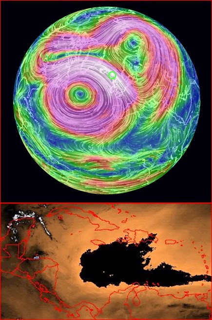
The Caribbean is still relatively peaceful. The black region indicates very dry air. Belize had a shower early morning but the day has been sunny and warm. Little change is expected.

Monday, January 5, 2015

This is the latest Upper Air wind at 10 mb above the Earth. Looks like a blocking High Pressure has formed east of Newfoundland Canada. This is going to keep most of North America in the deep freeze. meanwhile down here in Belize the cold front has stalled north of the Yucatan and will likely disappear. I new cold front should follow in a few days.
The cold front has moved further south and getting close to the Yucatan. The High Pressure has weakened and moved to the north towards Cuba. Belize has been covered in cloud this morning and now at 1320 we are getting some heavy showers. However, it is starting to clear along the coast so by about 1430 Belmopan should be seeing some better weather.

Sunday, January 4, 2015

Arctic air is getting ready to plunge southward. The upper wind speed over eastern Quebec is now 380 km/h.
A cold front is now cutting across the Gulf of Mexico. The High Pressure is still in the central Caribbean, so this area remains sunny and dry. Belize had more rain early last night, but is now sunny and dry. Total rain from the last 2 days was only 22 mm but seemed like a lot more. The next weather will likely be a reaction from the approaching cold front. The Caribbean High may try to block the front.

Saturday, January 3, 2015

The upper level High Pressure continues to be anchored in the central part of the Caribbean. As a result low clouds continue to bring frequent and brief showers into Belize. About 12 mm of rain has fallen since last night.
North America is still under the influence of the Arctic cyclone currently centered over Hudson Bay. Most of Canada is in the deep freeze.

Friday, January 2, 2015

After a sunny day there was a late afternoon shower. There will likely be more showers tonight. These frequent but brief showers we have been having in Belize is due to a line of showers sailing across the Caribbean from the direction of just south of east and being directed into the Gulf of Honduras ( as shown in the image). Sunday looks like a good day for clear sky before the next group of showers arrives on Monday.
Upper Left: The cold air is now covering most of North America. The upper wind over the eastern US is 330 km/h.
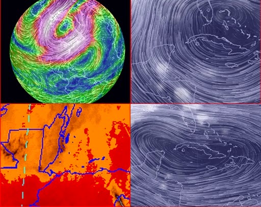
Upper Right: High Pressure still over Cuba which is directing the moisture off the warm water of the Caribbean directly into Belize.
Lower Left: The upper air is dry. However there was 18 mm of rain last night from low level clouds flowing in off the Caribbean. This morning the clouds have disappeared and it is now warm and sunny. The cold air is still being blocked by the High pressure ridge.
Lower Right: A view of what the High looked like yesterday Jan 1. It has not changed much over the past few days.
\