Thursday, December 23, 2010

Since may last report three cold fronts passed through during the first 2 weeks of December.
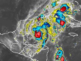
There was 50mm of rain with the first front the first 2 days of the the month. After that, there has been no rainfall. The night time temperatures have been cooler than normal for this time of year. The day time has been sunny and pleasant with low humidity. The image shows the persistent dry region around the Gulf of Mexico. However, some moisture is attempting to push in from the east at the present time. Belize is currently in a drought situation. Crops planted in November are now suffering from lack of moisture.

Thursday, November 25, 2010

The total rainfall from the weather system described on Nov. 18 was 150 mm or 5.9 in which occurred over a 5 day period ending  Nov.22. This rain was triggered by a slow moving cold front that was passing just to the north on Belize.

The weather for the past few days has been real nice. However,another cold front should be approaching for the weekend and this may set off some bad weather.

Thursday, November 18, 2010

Rainfall Warning


Large area of rain affecting Belize.

There is also a cold front approaching from the northwest.

Will report again tomorrow morning.

Thursday, November 11, 2010

November 11, 2010 Report


The weather has been cool and dry since the cold front passed through Belize Nov.5

This afternoon an area of low cloud is moving in from the Caribbean carrying with it some light rain showers.

Saturday, November 6, 2010

First Cold Front of season

Nov.3 strong cold front approaching, brought heavy rain 4 to 7 PM local time, 82 mm.

Nov. 4 cold front now well passed Belize followed by secondary front pushed by strong High Pressure.

Nov. 5 sunny and cool day. Morning of Nov. 6 very cool at sunrise, 60 F with clear sky. Quite cold for this time of year.

Tuesday, October 26, 2010

Hurricane Richard

Kindly disregard everything I said about "RICHARD" in my previous reports.

Hurricane Richard did not weaken as expected once making landfall. Instead it remained a category 1 hurricane, becoming smaller in diameter and more intense. It created a narrow path of destruction thorough the center of the country. Belmopan experience hurricane force winds October 24, from about 7:45PM to 11:45 PM with the eye of the storm passing over around 9:30PM.

I do not have any weather map pictures due to the fact that the electrical power failed at the same time as the hurricane arrived.

Sunday, October 24, 2010

Hurricane Richard

Richard has just barely made it to becoming a hurricane while about 90 miles east of the coast of Belize.
At this time the weather in Belmopan overcast but no rain. The wind is light from the west.
Right now it appears that the storm is becoming more ragged with the clouds on the north side becoming less dense. The wind field is very small and should affect only a small area of the coast with winds of 80 to 90 kph.
The wind should drop rapidly once the storm moves inland. Damage if any should be minimal.
I doubt if the rainfall will be as high as predicted (4 to 6 inches). Here in Belmopan we will lucky to get even 2 inches. Wind will be of no concern here.

Saturday, October 23, 2010

Richard

As predicted in my previous report, tropical storm Richard is now breaking apart.

Belize may experience a few thundershowers tonight but nothing unusual for this time of year.

Richard is a very small storm and may not last much longer as it is impacted by the proximity to land.

Friday, October 22, 2010

TS Richard Friday Night

Here is my current prediction for Richard:
This storm is going to break apart and the pieces will drift around until almost nothing is left of this storm. I do not agree with any of the conventional forecasts.
Why? There is no halo around the moon tonight. The solar activity is very low. The outflow centre has drifted well to the south of the storm. Dry air from Belize is being sucked into the west side of the storm. The upper air around the storm is electrically inactive. The surface air pressure is too high.

Thursday, October 21, 2010

TS Richard

The Richard system has elongated and connected with moisture over Costa Rica. Also the centre of outflow has shifted slightly to the east of Richard. Plus there is a dome of very dry air over Belize and surrounding area. All these factors are hampering the formation of Richard becoming a hurricane. My prediction at this time is that Richard will just wander around for awhile then dissipate, allowing a new system to develop east of Richard.

Richard


Here is my prediction for TS Richard:

Based on the fact that the Sun is fairly quiet, I think Richard will not develop into anything except a disorganized cluster of showers.

Will update later today.

Wednesday, October 20, 2010

No Rain

So far this month there has been only 7 mm of rain. We are in drought conditions.

Weather systems that form in the southwest Caribbean, are moving north then swinging northeast.

No rain is moving westward towards Belize.

Thursday, October 14, 2010

The Caribbean is under the influence of another Omega Block.

Except for what is left of Paula located at the western tip of Cuba, the Caribbean (including Belize) is clear.

Tuesday, October 12, 2010


Paula has moved north as I predicted last night, and has become smaller. The anticyclone centre has moved far to the southeast so Paula is being subjected to a strong southerly wind shear.

Belize will get no rain at all from this storm. Not good news for the farmers.

This morning the sky is clear.

Monday, October 11, 2010


Tropical Storm Paula formed this afternoon.

The storms outflow is located off to the northeast of the center of the storm and this should act as an anchor on its movement and cause the storm to move more towards the north rather than to the west.

Belize may only experience a few showers, drifting off from the extreme western edge of the system.

Friday, October 8, 2010

The low pressure trough is still stuck between Cuba and Panama. It refuses to move toward Central America.

The weather over Belize remains cool and dry.

Wednesday, October 6, 2010

The OMEGA block previously mentioned is finally breaking down allowing a band of light showers to approach Central America. I do not expect any significant rainfall from this system.

In general the weather making systems in the Caribbean are very weak. Geophysical activity is low and the sun is clear of any sunspots. Therefore, there is nothing out there to stir up a big storm.

Tuesday, October 5, 2010

The Caribbean is still under the influence of an "Omega" block.
Weather systems are pretty much stationary.
This block is making it sort of difficult for any hurricanes to form and move towards Central America.
The chances of Belize getting hit by a hurricane this year are becoming more remote by the day.

Friday, October 1, 2010

The weather over the past 2 days has been uneventful.

Just a nice cool westerly breeze and dry air. great weather for working outdoors.

We are in a weather block over the Caribbean basin where systems are not moving very much. Just forming and collapsing over the same area. Going to see what happens tomorrow.

Wednesday, September 29, 2010


This is what is left of Tropical Storm NICOLE. The storm produced severe flooding in Jamaica.

The storm has little affect on Belize. Just some scattered showers and a refreshing west wind.

Monday, September 27, 2010

A 1003 mb low just off northern Belize this evening, generated a moderate thunder shower which covered an area from Belmopan to northern Belize. This system did not produce much rainfall, maybe only 12mm.

By 9PM local time the storm cell had dissipated. However, shortly after 9PM the system re-developed and rain continued for most of the night. By the next morning I measured about 40mm of rainfall. This low pressure was probably connected with tropical depression 16 which was soon to become tropical storm NICOLE.

Sunday, September 26, 2010

TD Matthew is now history and has disappeared over Mexico.
At my location I measured only 50 mm of rainfall due directly to Matthew.

Today is sunny and about 31C. There is a lot of activity in the Caribbean southeast of Jamaica and this may head this way for Tuesday.

Saturday, September 25, 2010


TS Matthew has weakened considerably and is no longer a threat to Belize.
Only the southern most part of the country has received significant rainfall.

Friday, September 24, 2010

TS Matthew

The storm has considerably weaken since my last report.

The rainfall may be much less than previously anticipated.

I do not expect the storm to survive the night!

Position of Tropical Storm Matthew, 24 Sep 2010 at 2115 UTC or 5:15 EST
Belize should start feeling the effects of the storm sometime just before midnight.

We may get 10 to 15 cm of rainfall by this time tomorrow.

Tropical Storm Matthew has changed course and is now heading in a direction more to the south of Belize. This means that the winds will be greatly reduced in strength. However, we may receive some significant rainfall which could cause some serious flooding, especially in the south.

Will make an update later today.

Thursday, September 23, 2010


Tropical Storm Matthew appears to becoming better organized. The present course is directly for Belize.

It may not produce any damaging wind but we could see some serious flooding, especially in the south were they already have had too much rain and the roads are in bad condition right now even before the storm arrives.

Wednesday, September 22, 2010


This photo was taken this morning, Sep 22.
Shows that the upper air is becoming more unstable.
There is currently a lot of shower activity scattered about Caribbean. This activity is gradually moving west towards Central America. There is currently a 60% chance that this activity could develop into a tropical depression in the coming days.

Sunday, September 19, 2010

Continuation of hot, dry weather. There is very little weather activity in the Caribbean. Next report Sep. 22

Wednesday, September 15, 2010

The tropical depression mentioned in the September 12 report, developed into a tropical storm called KARL. This Storm is currently crossing the coastline of the Yucatan as show in the map. Here in Belmopan the sky is overcast with light rain and a light wind from the west.

The rainfall measured at my site was only 9 mm. The storm appears to be weakening as it moves inland.


September 14, 2010
This is a picture of the sunset taken before the arrival of tropical storm Karl.

Sunday, September 12, 2010

The remnants of tropical depression Gaston passed over Belize overnight. This produced a light thunder shower between 3:30 and 4 AM Sunday morning before sunrise. Measured 15.5 mm rain. Sunday morning was cloudy and cool, a nice change from the heat of the past 8 days.
I am keeping an eye on a large area of low pressure now southeast of Jamaica. This area has a medium potential of developing in a tropical depression in the next couple of days.

Wednesday, September 8, 2010

Sunday, September 5, 2010

These storm clouds are actually far away to the west in Guatemala.


Areas to the west of Belize are having a considerable amount of rain with flooding, especially in southern Mexico. Today, Belize is back in hot, dry weather. There is no sign of rain.


Wednesday, September 1, 2010


An unusual situation has occurred. The upper air layer has fractured over the western part of Belize in such a way that for the top half the flow is towards the northeast and for the lower half, the flow is in the opposite direction. This has allowed an area of rain showers to expand eastward in to Belize from Guatemala. As a result the northwestern part of Belize is experiencing moderate rainfall at this time about one hour before midnight. Normally there should have been clear sky at the moment.
The rainfall was measured next morning and found to be 0.56 inches or 14 mm.

Monday, August 30, 2010

The storm cell mentioned in the last report gained strength after midnight and passed to the south of Belmopan. There was a 15 minute period of intense lightening followed by loud thunder. The rainfall in Belmopan amounted to about 40 mm., but could have higher to the south near the centre of the storm. Following this storm, we are back in a dry northerly upper air flow, therefore the rest of the week should be good weather.

Sunday, August 29, 2010

The upper air has become more erratic. A storm cell is moving in from the southeast and may produce some activity. More on this later.

Friday, August 27, 2010

Upper Air pattern still has not changed. We are still in a dry northerly air flow.

Wednesday, August 25, 2010

Weather pattern still controlled by dry, northerly upper air. This pattern is limiting the development of any tropical storms in the area. There are signs that this pattern may be breaking soon and will make a report as soon as this occurs.

Friday, August 20, 2010

Yesterday's tropical wave has stalled and dissipated. No rain today. There is a slight chance that the system could redevelop tonight. Looks like there will be no significant weather until around the time of the next full moon, August 24, next Tuesday.

Thursday, August 19, 2010

A tropical wave is headed this way and may bring some storms with it tomorrow. Will update this report later today.
Update Thursday at 7PM. There does not appear to be much rain associated with the approaching tropical wave. Will see how things look Friday morning.

Monday, August 16, 2010

Sunday, August 15, 2010

In spite of a few brief showers the last few days, we are still in the "Little Dry" season.
The Saharan Air Layer has been expanding off the coast of Africa the past few days, so this should discourage the possible development of any tropical depressions.

Tuesday, August 10, 2010

We are now at the beginning of what is locally known as the "Little Dry" where we have several weeks of little or no rainfall.

Monday, August 9, 2010

After a moderate shower just before sunrise, the dry weather has finally arrived. This dry period should last at least 4 days.

Sunday, August 8, 2010

Dry weather not here yet. There was more rain this morning and more showers this afternoon. In fact there is a large rain cloud approaching right now. So far in August there has been over 8 inches (203mm) of rain, which is an average of one inch per day. Already above normal for this time of year.

Saturday, August 7, 2010

Weather along the wave has weakened. There should now be a gradual clearing trend with drier weather on the way.

The Tropical Wave is now affecting the region this morning with steady rainfall. Will update in 4 hours.

Friday, August 6, 2010


The second leg of the tropical wave is approaching. This system looks threatening. Will have to see how it looks this afternoon.

Thursday, August 5, 2010

A Thunderstorm developed suddenly around 2:30 PM local time and lasted for about 1 hour. Rainfall measured was almost 2.2 inches (55mm). The affected mainly the central and northwest part of the country. There was little rain along the coast. This storm appears to taken some of the energy out of the approaching tropical wave.
Good weather this morning. The tropical wave mentioned yesterday is still active and now predicted to arrive Friday night and into Saturday so it may be another wet weekend. Here is the projected position of the wave for Saturday.

Wednesday, August 4, 2010

More rain last night, 33.0mm, but clearing at sunrise. We have had 80 mm rain so far in August. Watching for the development of a storm for this weekend. Too soon to make a prediction. There is a high amplitude tropical wave associated. Also activity on the sun could stir up some bad weather in 3 days.

Tuesday, August 3, 2010

An extensive area of rain developed over the northern part of the country this afternoon. Now we are getting too much rain. The ground is completely saturated. There appears to be a complex set of tropical waves in the area.

Monday, August 2, 2010

Weather over the past 3 days has been uneventful. Just a few afternoon showers due to daytime heating. There is a weak tropical wave to the east which will probably allow these scattered showers to continue for awhile. No significant storms in the immediate area.

Saturday, July 31, 2010

The disturbance approaching the coast yesterday has dissipated this morning and is no longer a threat.

Friday, July 30, 2010

Very quite day, just a few light showers. Watching an area straight east and south of Cuba. May be a problem for tomorrow, too early to tell.

Thursday, July 29, 2010

Looks like another tropical wave is developing to the east. Some Thunder Showers already approaching. The Saharan air mass has backed off and some new moisture is moving in from the southern Caribbean.
July 29 at 7PM
It is now just after sunset and the sky has cleared after a day of scattered showers. Since last Sunday night there has been about 5 inches of rain (125 mm).

Tuesday, July 27, 2010

The rain ended about 10:00 AM local time and the sky cleared by 11 AM. Total rainfall from last night till this morning was 45.7 mm. Total rainfall from this system has been almost 100 mm. Some parts of the country have flooding, and some bridges are under water. The ground is pretty well saturated now.
Most of the open water of the Caribbean are under clear skies. However, over land, showers can occur at any time.
The weather system discussed over the past few days has persisted and produced a fair amount of rain last night ans early this morning. Will post how much rainfall measured as soon as I check the rain gauge.

Monday, July 26, 2010


The Tropical Wave has just hit at 1330 LT with gusty wind and heavy rain. The storm cell grew rapidly as the wave moved inland. Will add more to this later.
Here is the map:
There was some rain overnight, about 20 mm, from the system described yesterday. Last night was the full moon and very often rain does occur here around the time of the full moon.
This morning it is foggy. The tropical wave responsible for this weather has not yet passed by so there may be a few more showers on the way.

It is now noontime and it is still overcast.

Sunday, July 25, 2010

I am now predicting that the Saharan Air Mass is going to win and we are going into an indefinite period of very little rainfall. Not good news for agricultural crops that depend on adequate moisture. At this time I do not agree with the forecast of a more active than normal hurricane season. Storms that form, appear to rapidly dissipate. Most of the weather action is taking place along the Pacific coast of Central America and Mexico. Rain that does occur on the Belize side seems to be often due to a backlash from the west or southwest. But the good news is that the chance of severe flooding seems remote, until October at least.

Hope we get some rain in the next few days. There is much drier air to follow. Here is the Saharan Dry Air Map
Storm system getting closer.
This cell is about 70 miles to the east.
Band of showers about 400 Km to the east. May arrive in 7 hours?

Saturday, July 24, 2010

First day of this weather blog.
Nice weather today. No bad weather in sight.