Kindly disregard everything I said about "RICHARD" in my previous reports.
Hurricane Richard did not weaken as expected once making landfall. Instead it remained a category 1 hurricane, becoming smaller in diameter and more intense. It created a narrow path of destruction thorough the center of the country. Belmopan experience hurricane force winds October 24, from about 7:45PM to 11:45 PM with the eye of the storm passing over around 9:30PM.
I do not have any weather map pictures due to the fact that the electrical power failed at the same time as the hurricane arrived.
Tuesday, October 26, 2010
Sunday, October 24, 2010
Hurricane Richard

At this time the weather in Belmopan overcast but no rain. The wind is light from the west.
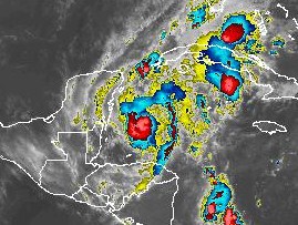
Right now it appears that the storm is becoming more ragged with the clouds on the north side becoming less dense. The wind field is very small and should affect only a small area of the coast with winds of 80 to 90 kph.
The wind should drop rapidly once the storm moves inland. Damage if any should be minimal.
I doubt if the rainfall will be as high as predicted (4 to 6 inches). Here in Belmopan we will lucky to get even 2 inches. Wind will be of no concern here.
Saturday, October 23, 2010
Richard

Belize may experience a few thundershowers tonight but nothing unusual for this time of year.
Richard is a very small storm and may not last much longer as it is impacted by the proximity to land.
Friday, October 22, 2010
TS Richard Friday Night

This storm is going to break apart and the pieces will drift around until almost nothing is left of this storm. I do not agree with any of the conventional forecasts.
Why? There is no halo around the moon tonight. The solar activity is very low. The outflow centre has drifted well to the south of the storm. Dry air from Belize is being sucked into the west side of the storm. The upper air around the storm is electrically inactive. The surface air pressure is too high.
Thursday, October 21, 2010
TS Richard

Richard

Here is my prediction for TS Richard:
Based on the fact that the Sun is fairly quiet, I think Richard will not develop into anything except a disorganized cluster of showers.
Will update later today.
Wednesday, October 20, 2010
No Rain
So far this month there has been only 7 mm of rain. We are in drought conditions.
Weather systems that form in the southwest Caribbean, are moving north then swinging northeast.
No rain is moving westward towards Belize.
Weather systems that form in the southwest Caribbean, are moving north then swinging northeast.
No rain is moving westward towards Belize.
Thursday, October 14, 2010

Tuesday, October 12, 2010
Monday, October 11, 2010

Tropical Storm Paula formed this afternoon.
The storms outflow is located off to the northeast of the center of the storm and this should act as an anchor on its movement and cause the storm to move more towards the north rather than to the west.
Belize may only experience a few showers, drifting off from the extreme western edge of the system.
Friday, October 8, 2010
Wednesday, October 6, 2010
The OMEGA block previously mentioned is finally breaking down allowing a band of light showers to approach Central America. I do not expect any significant rainfall from this system.
In general the weather making systems in the Caribbean are very weak. Geophysical activity is low and the sun is clear of any sunspots. Therefore, there is nothing out there to stir up a big storm.
In general the weather making systems in the Caribbean are very weak. Geophysical activity is low and the sun is clear of any sunspots. Therefore, there is nothing out there to stir up a big storm.
Tuesday, October 5, 2010

Weather systems are pretty much stationary.
This block is making it sort of difficult for any hurricanes to form and move towards Central America.
The chances of Belize getting hit by a hurricane this year are becoming more remote by the day.
Friday, October 1, 2010
The weather over the past 2 days has been uneventful.
Just a nice cool westerly breeze and dry air. great weather for working outdoors.
We are in a weather block over the Caribbean basin where systems are not moving very much. Just forming and collapsing over the same area. Going to see what happens tomorrow.
Just a nice cool westerly breeze and dry air. great weather for working outdoors.
We are in a weather block over the Caribbean basin where systems are not moving very much. Just forming and collapsing over the same area. Going to see what happens tomorrow.
Subscribe to:
Posts (Atom)