Sunday, October 27, 2013

The Upper Air ridge that has been trapping all this rain in a trough beneath it, is slowing dissolving so we should get a few days of better weather. However, there is another tropical wave off to east of the Caribbean which may cause some trouble sometime late Thursday into Friday.
More heavy rainfall this morning. Storm centred south of Dangriga. Belmopan actually on the northern edge. Must be some serious flooding to the south. Have measured 110 mm or over 4.3 inches for last night and up to 10:30 this morning. Three day total now about 13 inches. The storm cell should now begin to dissipate.

Saturday, October 26, 2013

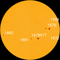
The sun has bee very active over the past few days. THE NEXT THREE DAYSSolar activity remains high. Sunspot AR1882 is crackling with M-class solar flares and poses a threat for more X-flares. The sun is turning this sunspot toward Earth. Over the next three days (Oct. 26-28), a series of CMEs created by the recent limb eruptions will deliver glancing blows to Earth's magnetic field, possibly sparking polar geomagnetic storms.
Moisture is still being trapped under a upper level anticyclone circulation and produced more rainfall last night, measured 2.35 inches or about 60 mm. The ground is now very saturated. There is clearing taking place starting in the south and moving north.

Friday, October 25, 2013

Heavy rainfall last night around Belmopan, measured 124 mm, total so far since yesterday is 6.2 inches or 157 mm. There is an upper air anticyclone circulation centred in southern Mexico setting up a block and uplifting the moisture flowing inland along the coast. The cold front remains just north of the Yucatan. The rain should be decreasing during today due to reduced convection.

Thursday, October 24, 2013

Seems like the cold front to the north has approached closer to Belize than expected. The previously mentioned tropical wave looks like it is colliding into the southern CW outflow from the cold front and generating some active weather over the land area. This is generating some significant rainfall. Also! SOLAR FLARE! Solar activity is high. On October 24th at 00:30 UT, Earth-facing sunspot AR1877 erupted, producing a powerful M9-class solar flare. NASA's Solar Dynamics Observatory recorded the blast: This could have helped trigger the development of the weather system.

Wednesday, October 23, 2013

The air to the east of Belize is still pretty dry (yellow area). A tropical wave is approaching but the top end of it has very little moisture. To the north is the remains of a cold front soon to be reinforced by a fresh outbreak of colder air in the southern States. Belize may get some rain but probably not very much due to lack of strong convection.

Saturday, October 19, 2013

Since the 22nd of September there has been only 43 mm of rain. A large upper air cell of High Pressure has been sitting over the central Gulf of Mexico keeping the area around the Yucatan dry for the past 3 weeks. This cell has finally started to collapse allowing more moist air to flow into the NW Caribbean. Will follow this change in air mass to see if there is a return to rainy weather.