Reported by Don Thompson at location in Belmopan 17'15" N, 88'47" W
Tuesday, March 26, 2013
The expected rainfall from the passage of a cold front has not occurred. Overnight and early this morning Belmopan received only 1 or 2 mm of rain, barely enough to dampen the ground. The chance of more rain in the next few days is low.
Sunday, March 24, 2013
Storm cell rapidly developed to the north west of Belize. Will probably not move into my location and should weaken quickly in a few hours. The cell was generated by an approaching cold front advancing across the Gulf of Mexico.
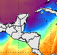
Monday, March 18, 2013
The warm air started returning last night so the temperature is getting back to normal. Some upper air cells developed during the mid afternoon as shown in the image ( the orange patches) with the tops being shredded by a strong SW to NE wind shear.
Friday, March 15, 2013
The cold air mass has pushed deep into the southern region of Central America. This is keeping the night temperature pretty cool for this time of year. There is not yet any sign of the warm air returning.
Tuesday, March 12, 2013
Rainfall overnight due to approach of Cold Front measured to be 53 mm or just over 2 inches. Looks like the main area of the cold air mass will roll across the Gulf of Mexico to the north of the Yucatan. Belize will probably not get too cool.
Monday, March 11, 2013
A fairly strong Cold Front is pushing across the Gulf of Mexico and this has ploughed up a line of showers along the east side of the Yucatan. Some showers have reached as far south as Belmopan. Will check how much rain in the morning.
Sunday, March 3, 2013
A strong cold front crossed Belize last Friday and pushed all the way down to Panama. There was very little rainfall associated with the front, measured only 5 mm. by Friday night. A cold High pressure cell now sits almost directly over Belize. We can expect a cold night tonight, maybe the the coldest night of this winter season.
Monday morning: Did not get as cold as expected last night.
Got down to about 63F or 17C. However tonight may be colder than this.