Wednesday, September 29, 2010
Monday, September 27, 2010
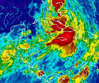
A 1003 mb low just off northern Belize this evening, generated a moderate thunder shower which covered an area from Belmopan to northern Belize. This system did not produce much rainfall, maybe only 12mm.
By 9PM local time the storm cell had dissipated. However, shortly after 9PM the system re-developed and rain continued for most of the night. By the next morning I measured about 40mm of rainfall. This low pressure was probably connected with tropical depression 16 which was soon to become tropical storm NICOLE.
By 9PM local time the storm cell had dissipated. However, shortly after 9PM the system re-developed and rain continued for most of the night. By the next morning I measured about 40mm of rainfall. This low pressure was probably connected with tropical depression 16 which was soon to become tropical storm NICOLE.
Sunday, September 26, 2010
Saturday, September 25, 2010
Friday, September 24, 2010
TS Matthew
The storm has considerably weaken since my last report.
The rainfall may be much less than previously anticipated.
I do not expect the storm to survive the night!
The rainfall may be much less than previously anticipated.
I do not expect the storm to survive the night!
Tropical Storm Matthew has changed course and is now heading in a direction more to the south of Belize. This means that the winds will be greatly reduced in strength. However, we may receive some significant rainfall which could cause some serious flooding, especially in the south.
Will make an update later today.
Will make an update later today.
Thursday, September 23, 2010
Tropical Storm Matthew appears to becoming better organized. The present course is directly for Belize.
It may not produce any damaging wind but we could see some serious flooding, especially in the south were they already have had too much rain and the roads are in bad condition right now even before the storm arrives.
Wednesday, September 22, 2010
This photo was taken this morning, Sep 22.
Shows that the upper air is becoming more unstable.
There is currently a lot of shower activity scattered about Caribbean. This activity is gradually moving west towards Central America. There is currently a 60% chance that this activity could develop into a tropical depression in the coming days.
Sunday, September 19, 2010
Wednesday, September 15, 2010
The tropical depression mentioned in the September 12 report, developed into a tropical storm called KARL. This Storm is currently crossing the coastline of the Yucatan as show in the map. Here in Belmopan the sky is overcast with light rain and a light wind from the west.
The rainfall measured at my site was only 9 mm. The storm appears to be weakening as it moves inland.

September 14, 2010
This is a picture of the sunset taken before the arrival of tropical storm Karl.
The rainfall measured at my site was only 9 mm. The storm appears to be weakening as it moves inland.
September 14, 2010
This is a picture of the sunset taken before the arrival of tropical storm Karl.
Sunday, September 12, 2010
The remnants of tropical depression Gaston passed over Belize overnight. This produced a light thunder shower between 3:30 and 4 AM Sunday morning before sunrise. Measured 15.5 mm rain. Sunday morning was cloudy and cool, a nice change from the heat of the past 8 days.
I am keeping an eye on a large area of low pressure now southeast of Jamaica. This area has a medium potential of developing in a tropical depression in the next couple of days.
I am keeping an eye on a large area of low pressure now southeast of Jamaica. This area has a medium potential of developing in a tropical depression in the next couple of days.
Sunday, September 5, 2010
Wednesday, September 1, 2010
An unusual situation has occurred. The upper air layer has fractured over the western part of Belize in such a way that for the top half the flow is towards the northeast and for the lower half, the flow is in the opposite direction. This has allowed an area of rain showers to expand eastward in to Belize from Guatemala. As a result the northwestern part of Belize is experiencing moderate rainfall at this time about one hour before midnight. Normally there should have been clear sky at the moment.
The rainfall was measured next morning and found to be 0.56 inches or 14 mm.
Subscribe to:
Posts (Atom)


