Saturday, January 31, 2015

 The upper air polar Low is now centered at 74.9 N and 74.0 E and is on the Siberia side of the North Pole. The diameter of this circulation has been shrinking over the past week.
There is a mid level High Pressure east of Belize. The nights are not as cool as a few days ago due the the southerly return flow. The next Cold front is not due until later this coming week. Hope it will bring a few showers with it this time.

Tuesday, January 27, 2015

Cold High Pressure in the western Gulf of Mexico at 24.7 N / 95.9 W pouring very cold air down over Belize. Tonight be the coldest night of the winter season. The leading edge of the cold air is predicted to weaken starting tomorrow.

Monday, January 26, 2015

A powerful storm is developing off the east coast of the US as shown in the images. A series of fast moving Cold Fronts are invading the Gulf of Mexico keeping the weather in Belize cool and cloudy. The cloud cover is helping to moderate the night time temperature for tonight. However, for Tuesday night and Wednesday the nights may be very cool. Need some warm blankets.

Saturday, January 24, 2015

The position of the Cold Front can be seen in this cloud water image as the orange band from western Cuba to northern Honduras. The front will move a little further to the east and then become stationary before dissipating later in the week. The purple area in the upper part of the image is the location of the coldest and driest air.
This morning the cold front has crossed Belize and is now just off the coast and pushing into the Gulf of Honduras. Belize will be much cooler over the next 5 days as a strong High Pressure drifts across the north west Caribbean. There was only a brief light shower due to the passage of the front. The image on the right shows that the upper air polar circulation has changed over the past few days and has moved more towards Siberia.

Friday, January 23, 2015

A strong Cold Front (cold air in red) has almost reached Belize. High Pressure will build in behind this front keeping Belize very cool for the next 4 days. This will likely be the coldest period for Belize this winter season. The warm air (yellow) will be pushed to the south. Not sure at this time if we will experience much rainfall. Will see what happens in the morning.

Saturday, January 17, 2015

The western Caribbean has become much drier. Since December 25, 2014 I have measured 258 mm of rain or about 10 inches. This rainy period may now be over and the dry season is now beginning to take over. The image on the right show that the polar arctic circulation is now rotating eastward allowing milder air to move into North America. The cold fronts have been staying north of the Yucatan. This has resulted in the nighttime temperature in Belize to remain warmer than usual.

Thursday, January 15, 2015

No images today, nothing much to show. There is a mid level High near Belize at 18-69 North and 87-87 West that will be expanding to the south and east tomorrow. This will keep sunny and warm weather over Belize for the next few days.

Monday, January 12, 2015

 A weak cold front passed through the Yucatan during the day with the trailing end just brushing past Belize. Toady was sunny and warm but tonight it should be noticeably cooler.
The Upper Air winds are taking on a new pattern with a Low Pressure in the centre and smaller Highs on each side. The Arctic air is dipping down into North America again. However, a change to milder weather is suppose to arrive at the end of the week. Will see how this alters the wind pattern.

Sunday, January 11, 2015

There is a front cutting through the Gulf of Mexico which going to slowly move to the east then stall. Some drier air is moving towards Belize followed by an area of moisture now approaching Jamaica. The Upper area cells of Low and High pressure is slowly rotating counter clockwise, and should bring colder air back into North America. The Saharan Air is beginning to intensify so the dry season for Belize is not too far away.

Saturday, January 10, 2015

Very unusual weather condition. Belize is getting a lot of rain this afternoon. The rain is coming in off the Caribbean as shown by the yellow arrow. The rain falling out of low cloud. There is no sign of any vertical development. The water vapour image is all grey in colour. The solid Red arrow shows the direction of the sub-tropical jet stream which is passing directly over Belize with a speed of over 90 mph. Not sure why all this moisture is forming off Belize in the Gulf of Honduras.

Thursday, January 8, 2015


The area around Belize has become more cloudy with scattered showers. The High Pressure that was in the central Caribbean a week ago has mostly dissipated. The intense cold over eastern north America is beginning to moderate. The Upper High is still anchored and spinning in the same place south of Greenland. This is causing some misery to the middle east with cold and snow.

Wednesday, January 7, 2015

This is an image of the cloud water in the Atlantic and it also shows the boundary of the cold air.. The cold air is not plunging into Central America, instead it is expanding eastward into the mid Atlantic. I am watching the area of moisture that is approaching the north coast of South America. This could start to affect the weather in Belize in 4 or 5 days. The interior of North America is extremely cold at this time, many places below -20 C.

Tuesday, January 6, 2015

The polar high upper air is allowing the cold arctic air to invade the Middle East. "Bitterly cold weather accompanied by wind, sub-zero temperatures and snow is expected to hit the KSA (Kingdom of Saudi Arabia) on Wednesday and last until Sunday."
North America is fairly normal right now but a new blast of Arctic air is preparing to plunge south in a few days.
The Caribbean is still relatively peaceful. The black region indicates very dry air. Belize had a shower early morning but the day has been sunny and warm. Little change is expected.

Monday, January 5, 2015

This is the latest Upper Air wind at 10 mb above the Earth. Looks like a blocking High Pressure has formed east of Newfoundland Canada. This is going to keep most of North America in the deep freeze. meanwhile down here in Belize the cold front has stalled north of the Yucatan and will likely disappear. I new cold front should follow in a few days.
The cold front has moved further south and getting close to the Yucatan. The High Pressure has weakened and moved to the north towards Cuba. Belize has been covered in cloud this morning and now at 1320 we are getting some heavy showers. However, it is starting to clear along the coast so by about 1430 Belmopan should be seeing some better weather.

Sunday, January 4, 2015

Arctic air is getting ready to plunge southward. The upper wind speed over eastern Quebec is now 380 km/h.
A cold front is now cutting across the Gulf of Mexico. The High Pressure is still in the central Caribbean, so this area remains sunny and dry. Belize had more rain early last night, but is now sunny and dry. Total rain from the last 2 days was only 22 mm but seemed like a lot more. The next weather will likely be a reaction from the approaching cold front. The Caribbean High may try to block the front.

Saturday, January 3, 2015

The upper level High Pressure continues to be anchored in the central part of the Caribbean. As a result low clouds continue to bring frequent and brief showers into Belize. About 12 mm of rain has fallen since last night.
North America is still under the influence of the Arctic cyclone currently centered over Hudson Bay. Most of Canada is in the deep freeze.

Friday, January 2, 2015

After a sunny day there was a late afternoon shower. There will likely be more showers tonight. These frequent but brief showers we have been having in Belize is due to a line of showers sailing across the Caribbean from the direction of just south of east and being directed into the Gulf of Honduras ( as shown in the image). Sunday looks like a good day for clear sky before the next group of showers arrives on Monday.
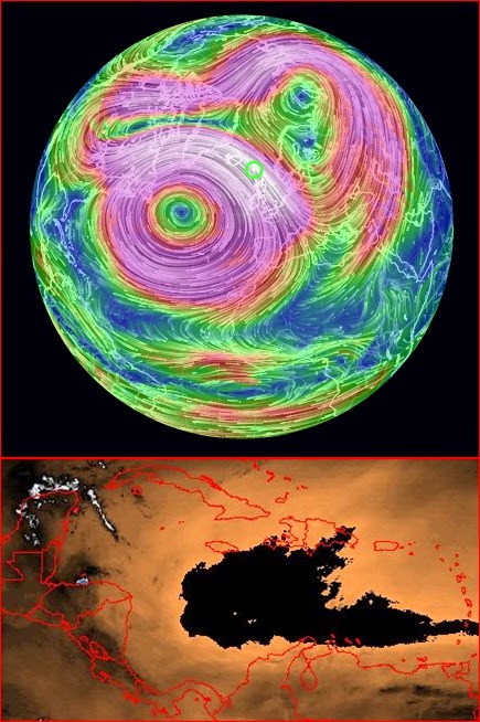
Upper Left: The cold air is now covering most of North America. The upper wind over the eastern US is 330 km/h.
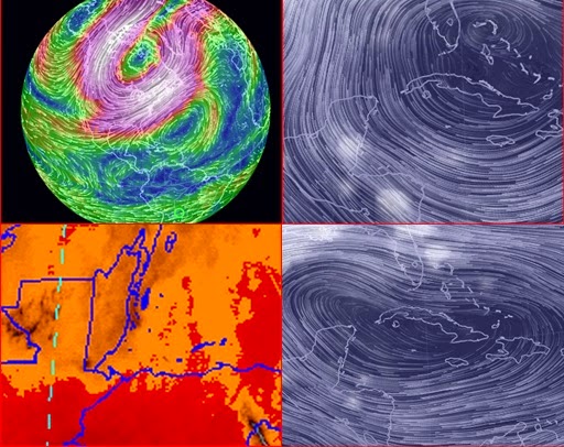
Upper Right: High Pressure still over Cuba which is directing the moisture off the warm water of the Caribbean directly into Belize.
Lower Left: The upper air is dry. However there was 18 mm of rain last night from low level clouds flowing in off the Caribbean. This morning the clouds have disappeared and it is now warm and sunny. The cold air is still being blocked by the High pressure ridge.
Lower Right: A view of what the High looked like yesterday Jan 1. It has not changed much over the past few days.
\